

 July 10, 2016
When I was still in the planning stages of this trip pretty much everyone I talked to (family, coworkers, strangers I had just met on the plane) would tell me how dangerous a woman hiking along was. While I would like to point out that it was statistically much more likely for me to die in my car on the drive to or from my runs, I did run the risk of slipping, hitting my head, and no one finding me. It probably did not help that the third park I was set to run in was the same park where James Franco had to saw his own arm off because he was an idiot and got his arms caught under a boulder. *** I don’t want to say anything negative about the guy who actually had this happen to him in real life, having the conviction to saw off your arm is no joke, but I watched the movie on the plane ride back from Utah, and the stuff James Franco was doing was pure idiocy!
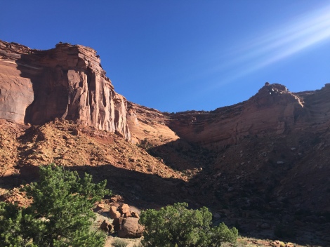
The park itself is actually divided into four pretty distinct sections. The part where James Franco was sits southwest of Horseshoe Canyon, while I was in the Island in the Sky District (ISD), which is to the north. Despite the fact that ISD is by far the most visited district of the park, it is so large and so vast, that there were very few times I saw anyone, and that risk of hitting my head and having no one find me actually seemed real.
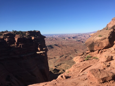
The day of my run I woke of perhaps a little too early to try and beat the heat of the day and started my first run around Neck Spring while I still had to strain my eyes to see each little rock pyramid. So to start off I kinda of hated the trail. It was challenging, there were plenty of uphill battles, brush, and instances of realizing that I was no longer on the trail, but as both the sun and I climbed higher into the canyons I began to see this:
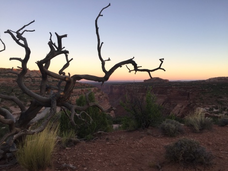
And I will be honest, no picture can really do it justice. The vistas spanned on for miles, and as it got lighter I was also able to actually see where I was going, making the run much more enjoyable. If you factor in the few times I went a little off the trail and had to circle back I had gone about 7 miles.
Next was Mesa Arch, which is really awesome, but not a run, it was even shorter than what you see on the map and is full of people. Worth seeing, just don’t plan on running it.
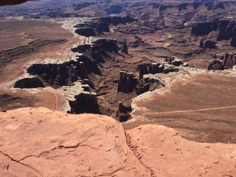
After snapping my selfie there I moved on to what I thought was going to be a nice 8 mile loop going out to Murphy Point and running to Murphy Hogback. The first mile or two of the trail were great, easy to follow and pretty flat. At the fork I went left to avoid some other hikers, figuring I would just loop back around. About a mile down I came to this great vista of what looked to be a 2,000 ft cliff. Great, I stopped, enjoyed the view for a second, and then I realized that the trail continued down the steep 2,000 ft drop. We are not going to talk about whether or not this was a smart idea, we are going to talk about the fact that I made that cliff my bitch. This is what it looked like from the bottom:
After climbing down there was what seemed to be an endless plateau of nothingness. I ran about another three miles before I realized there was nothing in site, and since I was not sure I was even on the Murphy trail anymore I decided to do what my mother would want me to do, and turn around before I die of heat exhaustion in a desert where no one would find me. So I climbed back up, ran back to the car, and was so full of adrenaline, that I went and ran almost every other trail in ISD.
White Rim Overlook
Aztec Butte
Upheaval Dome
By the end of the, my third day, I had run 58 miles and 78,500 elevation change and was on such an adrenaline rush I felt like I could have run 58 more (but also felt like I needed to do the world a favor and take a shower).
Overall, here is how I would rate the park:
| Trait | Rating (1-10) |
| Difficulty | Medium/Hard – Unless you are talking about walking up to a viewpoint, even the easiest trails include pretty steep climbs and pretty severe drops |
| Length | Varies. Some trails are just a few miles, and on some, like the White Rim Road, I think you actually need DAYS to finish. |
| Trail | 8 – Amazingly challenging, but you can get lost if you are not careful |
| Vista | 9 – You will be amazed at how desolate of a place you are in. Especially near the White Rim Overlook |
| Crowd Level | Desolate to Low – It was very rare to see anyone on the longer trails, but you would see some on the shorter trails. Upheaval Dome felt like a circus, so the earlier and the farther the better if you are looking to avoid the crowds |

Pingback: Trail Running Bucket List | The Traveling Trail Runner·
Pingback: The Beaches and Town of San Jose del Cabo, Mexico | The Traveling Trail Runner·